 www.geodatenkatalog.de (S1L)
Contact for the resource
Federal Institute for Geosciences and Natural Resources
79 record(s)
Provided by
Type of resources
Available actions
Topics
Keywords
Contact for the resource
Service types
-
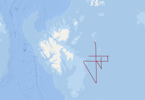
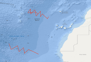
The PANORAMA-2 research cruise was carried out between August 15th and September 20th 2015 aboard the Italian research vessel OGS Explora, like the PANORAMA-1 cruise in 2013. The intended survey area was the European sector of the Arctic east and southeast of the Svalbard archipelago in the area of the northern Barents Sea. Main target of the PANORAMA-2 cruise was the acquisition of new geophysical data and the probing of surficial sediments in the underexplored area of the Sørkapp Basin and Olga Basin. In the course of the 20 day lasting Leg1 of the PANORAMA-2 cruise geophysical data acquisition was carried out. About 1750 km of 2D multi-channel seismic data were acquired and about 350 km of wide angle seismic data by means of sonobuoys. Sediment echosounder data, multi-beam data, gravity data and geomagnetic data were acquired during the entire cruise in a 24/7 mode within the survey area. After a 1-day stopover in Longyearbyen for a crew change of a part of the scientific crew, the research vessel OGS Explora returned to the survey area for another 11 days. During Leg-2 of the PANORAMA-2 cruise the surficial sediments were sampled by means of gravity corer, multi corer and dredge at 34 stations all together. Sediment sampling was carried out during day-light times only. Night times were used for acquisition of geomagnetic data, gravity data, sediment echosounder data and multi-beam data.
-
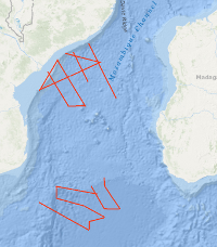
From 15th September to 26th October 2007 BGR together with the German Alfred-Wegener Institute for Polar and Marine Research (AWI), Bremerhaven, the French Institutes from Brest Institut Français de Recherche pour l'Exploitation de la Mer (IFREMER) and Institut Polaire Français Paul-Emile Victor (the French Polar Institute, IPEV) and the Portuguese Institute Laboratório de Tectonofísica e Tectónica Experimental (LATTEX) conducted a marine geophysical research cruise on the French research vessel R/V MARION DUFRESNE. The cruise BGR07 MoBaMaSis consisted of two legs MD163 off Central Mozambique and MD164 off Southern Mozambique. The main research objective was to contribute to a better understanding of the initial breakup and the early opening of the Eastern Gondwana.
-
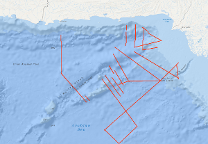
The Sonne Cruise SO122 was carried out by the Federal Institute for Geosciences and Natural Resources (BGR, Hannover) from 3rd August to 9th September 1997, in cooperation with GEOMAR (Kiel), the National Institute of Oceanography (NIO, Karachi) and the Hydrocarbon Development Institute of Pakistan (HDIP). During the joint project with R/V SONNE the Makran accretionary wedge off Pakistan should have been investigated in detail with multi-channel reflection seismics, magnetics and gravimetry. Intense fishery offshore Pakistan forced a change of the area of investigation to the south with the following objectives: investigation of the crustal structure and occurrence of the bottom simulating reflector (BSR) in the Makran accretionary wedge; investigation of the structure of the Murray Ridge System in order to reconstruct the geodynamic evolution of the eastern Indian Plate margin; determination of the origin of the crust underlying the Indus Fan and reconnaissance of the sedimentary history of the Indus Fan in order to reveal the uplift and erosion history of the Himalayas.
-
On the F.S. POLARSTERN cruise ANT-IV/3 (6th December, 1985 - 13th March, 1986) multichannel seismic measurements were carried out in parallel with magnetic and gravimetric measurements on 33 lines with a total length of 6,263 km. 3,350 km of the multichannel seismic lines have been processed aboard. The geophysical studies were designed to investigate the structure and geological development of the Weddell Sea continental margin from meridians zero to 60°W, and to define suitable and safe drilling locations for Leg 113 of the Ocean Drilling Program. The main results of the geophysical studies are: (1) The discovery of an approximately N50°E trending failed drift basin, following the trend of a negative magnetic anomaly and a positive gravity anomaly. (2) The discovery of two extensive wedge-shaped and symmetric basement units around a failed drift basin between longitudes 40°W and 20°W. The seismic characteristics, i.e. seismic velocities of 4 km/s and an internally divergent pattern of reflectors suggest that both wedges are formed from extrusive/intrusive volcanic rocks. (3) The confirmation of a major plate tectonic boundary trending approximately N80°E to N60°E, i.e. the EXPLORA-ANDENES escarpment. (4) The confirmation of a glaciogenic progradational wedge beneath the shelf of the Weddell Sea Embayment, made up of several thousand metres of sediments. (5) The definition of 13 suitable and safe drilling locations for ODP-Leg 113.
-
In continuation of a fracture zone survey of BGR in 1985, there was a multichannel seismic survey of the Hayes Fracture Zone between 20°W and 27°W in the time from October 26th to November 11th, 1988. In spite of bad weather conditions, it was possible to collect a total of 1.760 km seismic and gravity data on 11 lines. From a first interpretation of the seismic monitor records on board it appears that the frequency of intra-crustal reflections in the records from the area west of 20°W is much less than on the records of the survey of the previous cruise in 1985. During a second leg in the time period from 14th November to 21th November 1988 an additional seismic survey of the Kane Fracture Zone took place with 7 supplementary profiles.
-
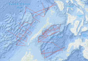
In the framework of the IDOE-SEATAR (International Decade of Ocean Exploration - Studies of East Asia Tectonics and Resources) Program, the Federal Institute for Geosciences and Natural Resources carried out a geophysical survey in the Sulu Sea during the period from March 11, 1982 to April 15, 1982 using the German research vessel R/V SONNE. The SONNE cruise no. SO-23 continued SEATAR-related studies of BGR which have been carried out during the Southeast Asian Cruise of the VALDIVIA (VA-16) in 1977. During SONNE cruise no. SO-23, multi-channel reflection measurements were carried out in parallel with magnetic, gravimetric, and sea-beam measurements on 21 lines with a total length of 3,300 km in the Sulu Sea. In the NW Sulu Basin, situated between the shelf of East Palawan in the north and the volcanic Cagayan Ridge in the south, a 50 - 100 km wide graben-like basin exists which is filled with thick Neogene and pre-Middle Miocene sediments. The basin trends east-northeast. At longitude 119°E it bends to a north-south direction. The dominating structural element within the sedimentary graben-like basin is a diapiric-chaotic zone about 25 km wide, which was only detectable west of longitude 120°E. The base of the elongated diapiric-chaotic zone, which might represent a tectonically mobilized equivalent of the Crocker Formation (Middle Miocene - Lower Oligocene) is difficult to define in the seismic monitor records. The configuration and the internal structural style of individual structures of the diapiric-chaotic zone, which can be followed over length of about 150 km, seem to resemble those of the oil-bearing province offshore western Sabah. In the eastern part of the NW-Sulu Basin east of longitude 119°E, several north-trending anticlines of presumably Middle Miocene age and locally volcanic intrusions of presumably Plio-Pleistocene age have been observed. During the second leg of the cruise SO-23 in the southeastern part of the South China Sea (April 16, 1982, to May 9, 1982) multi-channel seismic reflection measurements were carried out in parallel with magnetic, gravimetric, and sea-beam measurements on 19 lines with a total length of 3,570 km in the southeastern part of the South China Sea, including the area of the Dangerous Grounds. In addition, 2,280 km of profile was surveyed with only magnetics, gravity, and sea-beam measurements. A complex structural style was observed in the investigated part of the Dangerous Grounds, South China Sea, which is believed to be part of a microcontinental block which rifted from the continental margin of Asia in the Early Paleogene/Late Mesozoic time. There are prospective depocenters and structures trending NE-SW, E-W, and N-S in the southwestern part, i.e. the area west of longitude 117.5°E (units 2, 3, 4). Unit 4 contains a series of half-grabens with thick sedimentary infill. An imbricated melange of pre-Middle Miocene age seems to exist only off southern Palawan. The dominating structural trend in the area northeast of Reed Bank is NW-SE. Oceanic crust characterized by NW-trending magnetic lineations (anomalies 8 to 12 ?) was observed north of latitude 12°N and between longitude 118°E and the Manila Trench.
-
The BGR 1991 cruise with M.V. BIN HAI 511 was designed to study the variability of the oceanic crustal structure along flow-line profiles perpendicular to the ridge axis over Early Tertiary through Cretaceous old oceanic crust of the eastern Atlantic Ocean. Seismic data with a coverage of 3,000 % were acquired along four flow-line profiles with a total length of 4,194 km, and in addition 270 km of MCS data were collected during the period from 2nd October to the 3rd November 1991. The most intriguing new observation from the seismic flow-line profiles is the discovery of two huge oceanic crustal structures characterized by an internally divergent to planar pattern of reflectors having ubiquitous seaward dip. These remarkable structures were found within an about 1,300 km long oceanic crust segment of the eastern South Atlantic located between the Bode Verde Fracture zone in the north and the Rio Grande Fracture Zone in the south. These structures resemble the prominent wedges of seaward dipping reflectors on the widespread volcanic rifted continental margins described in the literature. They are interpreted to represent voluminous build-ups of layered extrusive rocks formed during three excessive episodes of volcanism that accompanied the Cretaceous opening of the South Atlantic. These episodes of excessive volcanism/magmatism are: An episode immediate prior to, and during the first stage of seafloor spreading in the South Atlantic, i.e. during about Hauterivian through about early Aptian; an episode of inferred subaerial and/or shallow marine volcanism along the central South Atlantic spreading ridge during the Albian; and an episode of inferred subaerial and/or shallow marine volcanism along the South Atlantic spreading ridge during latest Cenomanian/earliest Turonian through early Campanian.
-
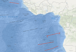
In the frame of the Continental Margin Study Program of the Federal Institute for Geosciences and Natural Resources (BGR, Hannover) marine geophysical measurements (48-channel reflection seismic, sono-buoy refraction, gravity and magnetic) were conducted over the Atlantic continental margin of Canada from 23th July to 7th August 1979 with S.V. EXPLORA (BGR79 leg 2). The survey on the Canadian continental margin was planned in cooperation between the Federal Institute for Geosciences and Natural Resources (BGR) and the Atlantic Geoscience Centre of the Geological Survey of Canada (Bedford Institute of Oceanography, Dartmonth, N.S.) on the base of existing Canadian multichannel seismic lines. A main target of the cruise was to acquire data which allow a comparison of the deep sedimentary basins offshore Nova Scotia with the already known basins offshore Morocco. The eastern part of the survey imaged complex structural deformation due to salt diapirs. The western seismic lines allowed to investigate the structural relationship between the Scotian Basin and the Georges Bank.
-
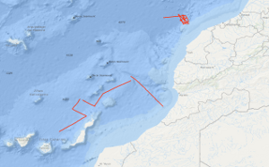
In the period from February 13th to March 2nd 1980 4,037 km of magnetic, gravity and bathymetric lines and 1,195 km of digital reflection seismic lines were recovered on the 2nd leg of METEOR cruise no. 53. Heat flow measurements have been performed on 13 stations; on two stations sonobuoy refraction measurements and dredging have been carried out. From a preliminary interpretation of the seismic monitor records the Mazagan Plateau is part of the Moroccan Meseta. Seawards of this stable swell lies the 75 km wide, downfaulted rift graben characterized by salt diapirs. A submarine body, 150 square kilometres large, lying at the foot of the Mazagan Escarpment in water depths of 3000 m - 3800 m beneath sea level, from which western flank few granitic fragments were retrieved, is interpreted as a subsided and tilted block of the Mazagan Plateau. The north-trending magnetic anomalies, discovered during METEOR cruise no. 46 within the Essaouira continental margin segment have also been recognized within the Tafelney Plateau segment, situated between latitudes 30°45'N and 31°30'N off Morocco. Two neo-volcanic zones were found west of the Conception Bank and west of the Betancuria Massif/Fuerteventura Is. The Mesozoic and Tertiary depositional sequences are highly deformed by small piercement structures interpreted as dykes within these zones.
-
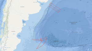
From 19th November to 19th December 2004 BGR conducted a marine geophysical cruise between 34°S and 36°S off Uruguay and between 46°S and 50°S off Argentine. The main research objective was to contribute to a better understanding of the initial breakup and the early opening of the South Atlantic. In continuation of our former work on the South Atlantic continental margins off Argentina, Brazil, Uruguay, Namibia and South Africa marine geophysical research (multi-channel seismics, refraction-/wide-angle reflection seismics, magnetics and gravity) was performed in close cooperation with the Argentine and Uruguayan authorities Comisión Nacional del Límite Exterior de la Plataforma Continental (COPLA) of Argentina and Servicio de Oceanograficia, Hidrograficia y Meteorologia de la Armada (SOHMA) of Uruguay. Multi-channel seismic lines with a total length of 3,754 km and additional 3540 km with the other geophysical methods were acquired . Along two lines refraction-/wide-angle reflection seismic work was carried out. The preliminary analyses of the new seismic data show different images of the crustal structures between Uruguay and southern Argentine with regard to the distribution and volume of offshore volcanic rocks (seaward dipping reflector sequences, SDRS) along the South American Atlantic margin. On the northern profiles between 34°S and 36°S one single well developed wedge of SDRS is present. Although the landward termination (‘feather edge’) on most of the lines is masked by multiples the average total width of the wedge across the margin seems to be 90 – 100 km and is very constant for this margin segment. This is strong contrast to the results from former cruises (BGR87, SO85 and BGR98) which covered the area between 38°S and 45°S. There, the SDRS showed distinct multiple wedges which in some places extend over 120 km across the continental slope. The investigation of the sedimentary section yielded that in the area off Uruguay widespread bottom simulating reflectors (BSR) are present. This indications for stable gas hydrates cover a total area of 7000 km2. One major aim of the cruise was to cover the transition between a volcanic passive margin and a non-volcanic passive resp. sheared margin. This was accomplished in the southern part of the investigated area. Two EW-trending profiles across the Argentine shelf into the Argentine Basin still show indications for SDRS but these structures are only 25 – 30 km wide. The profiles which extend from the NE to the SW crossing the Agulhas-Falkland Fracture Zone (AFFZ) onto the Falkland Plateau show the typical trend of a sheared margin. At the northern rim of the Falkland Plateau a set of small pre-rift half grabens were found indicating pre-rift extensional tectonic phases. The magnetic data in the area off Uruguay show lineations which are preliminary interpreted as chrons M0 to M3. This might indicate that the first (oldest) oceanic crust was created at a time around the magnetic polarity reversal between the normal interval M4 and the reversed interval M3 (126-127 Ma). Together with existing data from previous cruises this indicates that the breakup of the South Atlantic started further South because there magnetic chrons back to M9 (130 Ma) were identified. In the southernmost part of the margin at 47°S only the magnetic lineations M0 to M4 were identified in the oceanic domain Nevertheless, it is likely that between M4 and the assumed position of the continent ocean boundary/transition (COB/COT) older oceanic crust exists that for some reasons does not show correlatable lineations. The the free-air gravity map is dominated by the main topographic and structural features in the survey area. Rifted continental margins are characterized by prominent free-air gravity anomalies elongated parallel to the ocean-continent transition. The continental slope is considerably steeper in the North off Uruguay than in the South and thus the gravity high is much more pronounced in the North than in the South. The simple Bouguer anomaly map also shows the difference between the more gentle and wider continental slope in the South and the steeper slope in the North. The lowest Bouguer gravity values are found in the area of the basins on the continental shelf. Especially the Salado Basin in the prolongation of the Rio de la Plata and the Colorado Basin at about 40°S are indicated by Bouguer gravity anomaly highs. The interpretation by forward density modelling shows, however, the presence of SDRS units in the North of relative high density in the area of the continental slope. Whereas the modelling shows no indications for such volcanic bodies in the South. Although the MCS data indicate a small SDRS wedge but this body may be too small to cause an anomaly.From 17th April to 6th June 2003 BGR conducted a marine geophysical cruise between 30°S and 38°S off the Atlantic coast of South Africa. The main research objective was to contribute to a better understanding of the initial breakup and the early opening of the South Atlantic. In continuation of our former work on the South Atlantic continental margins off Argentina, Brazil, Uruguay and Namibia marine geophysical research (multi-channel seismics, wide-angle refraction seismics, magnetics and gravity) was performed in cooperation with the Petroleum Agency South Africa (PASA). Multi-channel lines with a total lenght of 3,260 km, and additional 1,365km, with the other geophysical methods were acquired. Combined onshore/offshore refraction seismic work in cooperation with GeoForschungsZentrum Potsdam (Germany) and the Council for Geoscience (South Africa) was also part of the program.